Using visualization to make open data accessible
Through a project partnership with the Senate Department for Integration, Labor and Social Affairs, ODIS explores how to use data visualization to make open data more accessible.
With the launch of our new website for the “Open Data Informationsstelle” (ODIS), we have also launched a new open data project: an exploration of the open data available around the topic of Grundsicherung, which is a form of basic income support provided by the government in Germany.
We developed this website in collaboration with the Senate Department for Integration, Labor and Social Affairs (German: Senatsverwaltung für Integration, Arbeit und Soziales, or simply SenIAS). This department publishes a significant amount of open data through the GSI Portal, but this portal is not widely known, and as a result, much of this valuable data (spanning both public health-related topics as well as data related to social and welfare policy) is currently going unexplored and unused. Moreover, much of the subject matter covered by data in the GSI Portal is complex and not always easily understood by laypersons unfamiliar with the specific terminologies used by the government to explain or describe a given policy or mechanism.
However, by analyzing and visualizing data, we can make these complicated subjects accessible to more general audiences and at the same time reveal insights valuable for a variety of groups, including politicians, administrative employees, and even citizens themselves.
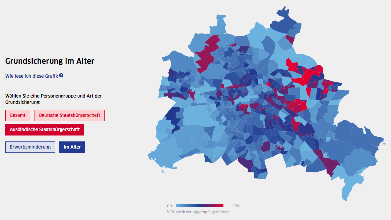
To illustrate this point, we worked with SenIAS to visualize data on the recipients of basic income support in Berlin. Our project features three key visualizations. The first is a map-based visualization that shows the distribution across Berlin of recipients of the two main kinds of income support: income support for senior citizens whose pensions are insufficient to cover their expenses, and income support for citizens who are unable to work to support themselves (for example, due to illness or a disability). This allows us to see where in the city there are particularly high concentrations of individuals receiving income support, which could in turn be used to identify areas where additional social support measures could be better targeted (for example, ensuring areas with a high number of income support recipients are adequately served by food banks or other types of social infrastructure).
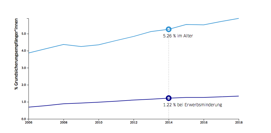
The project’s second key visualization explores trends in the number of income support recipients in Berlin. With a line chart, we can show how the percentage of recipients of both kinds of support has increased steadily over the last 12 years – a trend that many in Berlin are unaware of, our partners at the Senate Department noted.
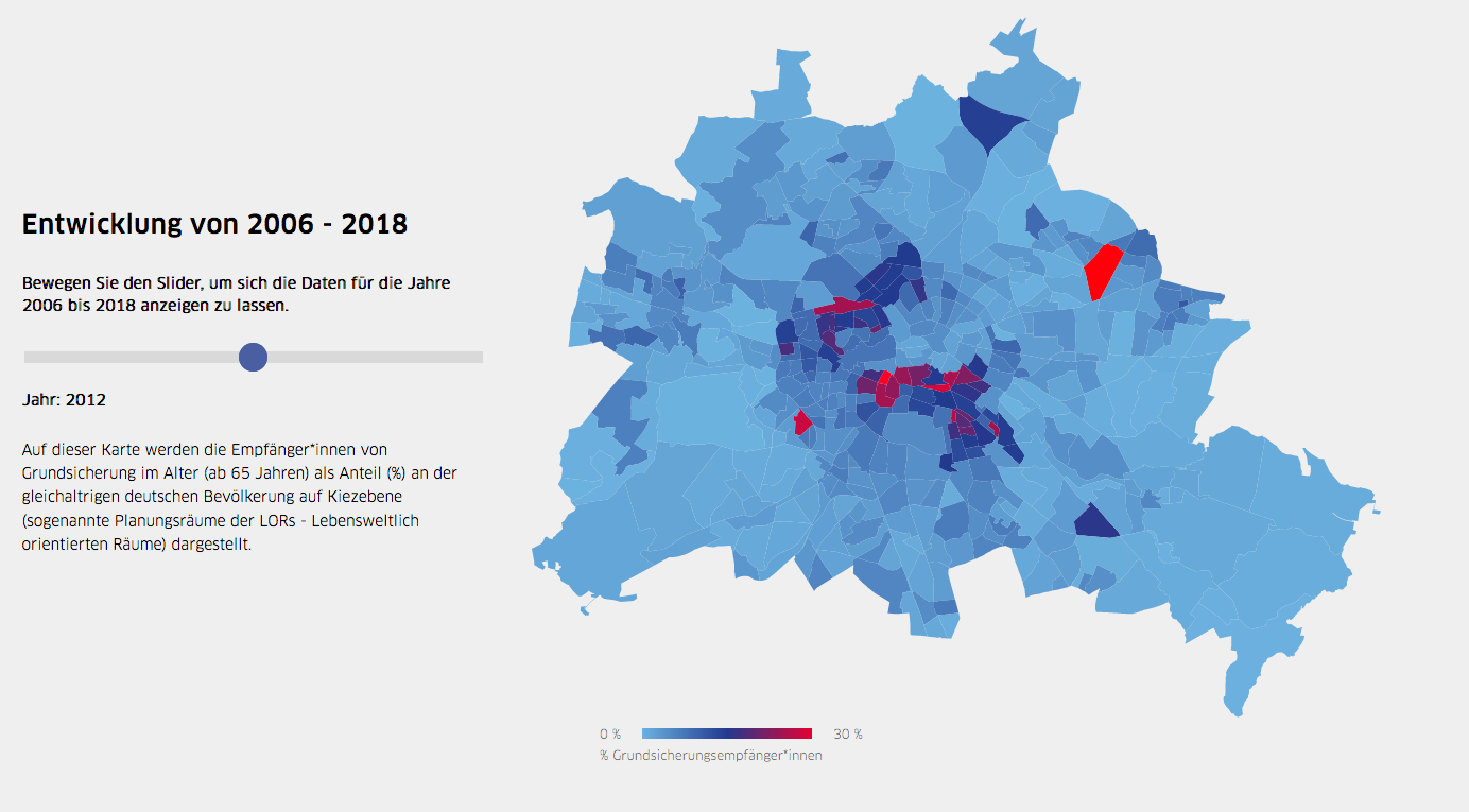
The third visualization offers a spatial perspective on these trends: it shows how the percentage of seniors receiving income support in various regions of Berlin has changed over the last 12 years. This perspective allows us to see how the increase of income support recipients in Berlin is not distributed evenly across the city – and thus that the potential impact of this increase is also not evenly distributed across the city.
To dive deeper into this topic, visit the project site here (available only in German). These are of course just some of the insights that are possible with this data – since it’s available as open data, anyone who wants to can explore the data further and do their own analyses. More information on the data sources is available at the bottom of the project’s website.